One sixth of the sky with the telescope SRG/eROSITA

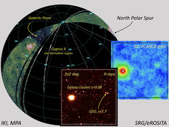
Current status of the all-sky survey in X-rays by SRG: about 1/6 of the entire sky has already been covered. Due to the survey geometry, the individual scans of the observatory intersect near the ecliptic poles, resulting in increased sensitivity. The inset shows a small region enlarged and a PLANCK map of the same region in comparison.
The image shows a map of half the sky in the 0.4–2 keV energy range, obtained by the SRG/eROSITA telescope. The axes of the observatory telescopes draw large circles in the sky passing through the north and south ecliptic poles. The dark band associated with the absorption of soft X-ray radiation by gas and dust in the Galaxy Plane is clearly visible on the map. The bright diffuse region on the right side of the map is the famous North Polar Spur, an area of increased brightness of radio emission in the form of an arc. Another bright area near the Plane of the Galaxy is the most powerful star-forming region in our Galaxy, known as Cygnus X. Outside of these areas, the X-ray radiation is dominated by numerous active galactic nuclei and clusters of galaxies.
The resolution of the map of the whole sky shown in the figure does not allow one to see individual sources, although more than ten thousand of them have already been registered. To illustrate the capabilities of the telescope, the inset shows a small portion of the sky (2x2 degrees) with better resolution. For comparison the PLANCK (ESA) SZ-map of the same region is shown. The place where the inset was taken from is shown in the large image as a small square near the North ecliptic pole. Near the ecliptic poles the individual scans of the observatory intersect.
The Spectrum RG Observatory continues to scan, and every day it adds a 1-degree-wide strip to this map. The images shown here are based on the data from the Russian share of observing time of the SRG/eROSITA telescope.


